Loading international directory
0 agents listed nowGrowing cityGrowing: help us fill this page
London, United Kingdom: LGBTQ+ friendly real estate guide
A data-first guide to London, United Kingdom for LGBTQ+ buyers, renters and people relocating: housing costs, legal protections, community venues, climate and daily life. Every figure carries a numbered source and a retrieval date.
Units
- LGBTQ+ venue records
- 57[1]
LGBTQ+ community map and venues in London
Venues, centers, health and social services and Pride events tagged as LGBTQ+ in OpenStreetMap and Wikidata. Both are volunteer-maintained, so treat this as a starting point.
- Community centers, health and social services (square)
- Bars, nightclubs, cafes and restaurants (circle)
- Shops, arts venues and Pride events (diamond)
- Other records (triangle)
- Plus sign: city center
Faded markers use the coordinate of the place a record is located in, not its own. The 40 numbered markers match the list below. No map tiles are used; no boundary is drawn because we have no outline source for this place.
- 26 bars
- 8 nightclubs
- 8 shops
- 7 other venues
- 3 community centers
- 3 arts and culture venues
- 2 Pride events
40 nearest records of 57
1. London LGBTQ+ Community Centre
community center · 1.2 mi1.9 km from center · 60-62 Hopton Street, London
OpenStreetMap tags: lgbtq=primary, community_centre:for=lgbtq, amenity=community_centre, wikidata=Q122212220
2. Triangle LGBTQ+ Cultural Centre
community center · 5 mi8 km from center
Wikidata class: LGBT community center
3. QUEERCIRCLE
community center · 5.9 mi9.5 km from center · 3 Barton Yard, London
OpenStreetMap tags: lgbtq=primary, community_centre:for=lgbtq, amenity=community_centre
4. Ku Bar
bar · 0.1 mi0.2 km from center · 29-30 Lisle Street, London
OpenStreetMap tags: lgbtq=primary, amenity=bar
5. Comptons of Soho
bar · 0.2 mi0.3 km from center · 51-53 Old Compton Street, London
OpenStreetMap tags: lgbtq=primary, amenity=pub, wikidata=Q5157187
6. Duke of Wellington
bar · 0.2 mi0.3 km from center · 77 Wardour Street, London
OpenStreetMap tags: lgbtq=primary, amenity=pub
7. Halfway II Heaven
bar · 0.2 mi0.3 km from center · 7 Duncannon Street, London
OpenStreetMap tags: lgbtq=primary, amenity=pub
8. Rupert Street
bar · 0.2 mi0.3 km from center · 50 Rupert Street, London
OpenStreetMap tags: lgbtq=primary, amenity=pub
9. The Friendly Society
bar · 0.2 mi0.3 km from center · 79 Wardour Street, London
OpenStreetMap tags: lgbtq=primary, amenity=bar
10. The Yard
bar · 0.2 mi0.3 km from center · 57 Rupert Street, London
OpenStreetMap tags: lgbtq=primary, amenity=bar
11. Admiral Duncan
bar · 0.2 mi0.4 km from center · 54 Old Compton Street, London
OpenStreetMap tags: lgbtq=primary, amenity=pub, wikidata=Q4683676
12. G-A-Y
bar · 0.2 mi0.4 km from center · 30 Old Compton Street, London
OpenStreetMap tags: lgbtq=primary, amenity=bar
13. Little Ku
bar · 0.2 mi0.4 km from center · 25 Frith Street, London
OpenStreetMap tags: lgbtq=primary, amenity=bar
14. Village
bar · 0.2 mi0.4 km from center · 81 Wardour Street, London
OpenStreetMap tags: lgbtq=primary, amenity=bar
15. Circa
bar · 0.3 mi0.5 km from center · 62 Frith Street, London
OpenStreetMap tags: lgbtq=primary, amenity=bar
16. The Retro Bar
bar · 0.3 mi0.5 km from center · 2 George Court, London
OpenStreetMap tags: lgbtq=primary, amenity=pub
17. King's Arms
bar · 0.5 mi0.8 km from center · 23 Poland Street, London
OpenStreetMap tags: lgbtq=primary, amenity=pub
18. Heaven
nightclub · 0.2 mi0.4 km from center · 10A Villiers Street, London
OpenStreetMap tags: lgbtq=primary, amenity=nightclub, wikidata=Q5694616
19. She Soho
nightclub · 0.2 mi0.4 km from center · 23a Old Compton Street, London
OpenStreetMap tags: lgbtq=primary, amenity=nightclub
22. The WayOut Club
nightclub · 2.3 mi3.7 km from center
Wikidata class: LGBTQ nightclub
23. Dalston Superstore
nightclub · 3.6 mi5.8 km from center · 117 Kingsland High Street, London
OpenStreetMap tags: lgbtq=primary, amenity=nightclub
24. Clonezone
shop · 0.2 mi0.3 km from center · London
OpenStreetMap tags: lgbtq=primary, shop=erotic
25. Prowler
shop · 0.2 mi0.4 km from center · 5-7 Brewer Street, London
OpenStreetMap tags: lgbtq=primary, shop=erotic
26. Prowler Red
shop · 0.2 mi0.4 km from center · 50 Old Compton Street, London
OpenStreetMap tags: lgbtq=primary, shop=erotic
27. Regulation
shop · 0.3 mi0.5 km from center · 13a Bateman Street, London
OpenStreetMap tags: lgbtq=primary, shop=erotic
28. Gay's The Word
shop · 1.1 mi1.7 km from center · 66 Marchmont Street, London
OpenStreetMap tags: lgbtq=primary, shop=books, wikidata=Q5528519
29. Fetish Freak
shop · 2.2 mi3.6 km from center · 76 Bolton Crescent, London
OpenStreetMap tags: lgbtq=primary, shop=erotic
30. Boys! Boys! Boys!
arts or culture venue · 1.1 mi1.7 km from center
OpenStreetMap tags: lgbtq=primary, tourism=gallery
31. Queer Britain
arts or culture venue · 1.8 mi2.9 km from center · 2 Granary Square, London
OpenStreetMap tags: lgbtq=primary, tourism=museum, wikidata=Q110687141
32. The Queer Comedy Club
arts or culture venue · 1.9 mi3 km from center · 9 Hewson Way, London
OpenStreetMap tags: lgbtq=primary, amenity=theatre
33. Pride London
Pride event · 0.8 mi1.3 km from center
Wikidata class: Pride parade
34. UK Black Pride
Pride event · 5.7 mi9.1 km from center
Wikidata class: Pride parade
35. G-A-Y Late
other venue · 0.4 mi0.6 km from center · 5 Goslett Yard, London
OpenStreetMap tags: lgbtq=primary, wikidata=Q3093022
36. Sweatbox Sauna & Gym
other venue · 0.5 mi0.8 km from center · 1-2 Ramillies Street, London
OpenStreetMap tags: lgbtq=primary, leisure=sauna
37. Pleasuredrome
other venue · 0.9 mi1.5 km from center · Arch 24 Cornwall Road, London
OpenStreetMap tags: lgbtq=primary, leisure=sauna
38. Vault
other venue · 1 mi1.6 km from center · 139-143 Whitfield Street, London
OpenStreetMap tags: lgbtq=primary, amenity=swingerclub
39. The Locker Room
other venue · 1.7 mi2.8 km from center · 6-8 Cleaver Street, London
OpenStreetMap tags: lgbtq=primary, leisure=sauna
40. The Joiners Arms
other venue · 2.7 mi4.4 km from center
OpenStreetMap tags: lgbtq=primary, wikidata=Q16995446
The other 17 records are in the machine-readable file for this city.
© OpenStreetMap contributors · Wikidata (CC0). OpenStreetMap data is available under the Open Database License; Wikidata is CC0. Names and addresses are shown as the sources state them.
Daily life in London
How people get around, plus counts of mapped transit stops, parks and everyday destinations near the city center.
- Public transit stops
- 444[5]91 per sq mi35.3 per sq km within 1.2 mi2 km of the center
- Rail and subway stops
- 30[5]6.2 per sq mi2.4 per sq km within 1.2 mi2 km of the center
- Parks
- 94[5]19 per sq mi7.5 per sq km within 1.2 mi2 km of the center
- Everyday destinations
- 1,088[5]897 per sq mi346.5 per sq km within 0.6 mi1 km of the center
OpenStreetMap counts reflect what volunteers have mapped and the area measured, so compare them between places with care.
Moving to London: a guide from the data
Every line below is generated from the sourced figures on this page. Nothing here is opinion or marketing.
Know your protections before you sign
- 18 legal topics could not be verified for London and are marked as such below.
Getting there and getting around
LGBTQ+ venues, centers and events (OpenStreetMap, Wikidata)
Questions to bring to any agent
General questions, not city data.
- Which neighborhoods fit my budget, and how do you know?
- How many LGBTQ+ clients have you represented, and can I speak to one?
- Which lenders and inspectors do you work with, and do you receive anything for referring them?
- How will you handle showings and offers if I am relocating from out of town?
- What is your fee, and when is it due?
Agents in London
Ranked by verified license, transaction-verified reviews and measured response time. Payment never changes this order.
No agents in London yet
Be the first. Founding agents get a permanent profile and first right on local leads.
Buying in United Kingdom as a foreigner
Property law in the United Kingdom differs between England, Scotland, Wales and Northern Ireland. For the current legal position on discrimination in housing, read the Equality and Human Rights Commission guidance. Unverified summary with no source cited. Confirm current rules with local counsel before you act.
Freehold and leasehold
Flats are often leasehold, so lease length, ground rent and service charges matter as much as price.
Taxes on purchase
Stamp duty applies to most purchases, and non-residents may pay a surcharge. Confirm current rates with a solicitor.
Conveyancing
A solicitor or licensed conveyancer handles the legal work between offer and completion.
| English | British English |
|---|---|
| Real estate agent | Estate agent |
| Closing | Completion |
| Lawyer for closing | Conveyancer or solicitor |
| Property inspection | Survey |
| Apartment | Flat |
| Closing tax | Stamp duty |
Read the buying abroad guide. Spanish and French pages are planned; hreflang alternates currently list: en, x-default.
London needs a founding agent
Featured city slotOne per city · Open now
Be the founding agent in London
Only 0 agents are here so far. The featured city slot comes with the Featured plan at $99 a month, with a lifetime price lock for the first 500 paid agents.
Relocating
Thinking about moving to London?
Tell us your budget, timeline and what you want your neighborhood to feel like. We will introduce you to agents who have helped others make the same move.
Share London charts
Each card is a standalone image that prints its own sources and date. Save it, post it, or drop it in a message.
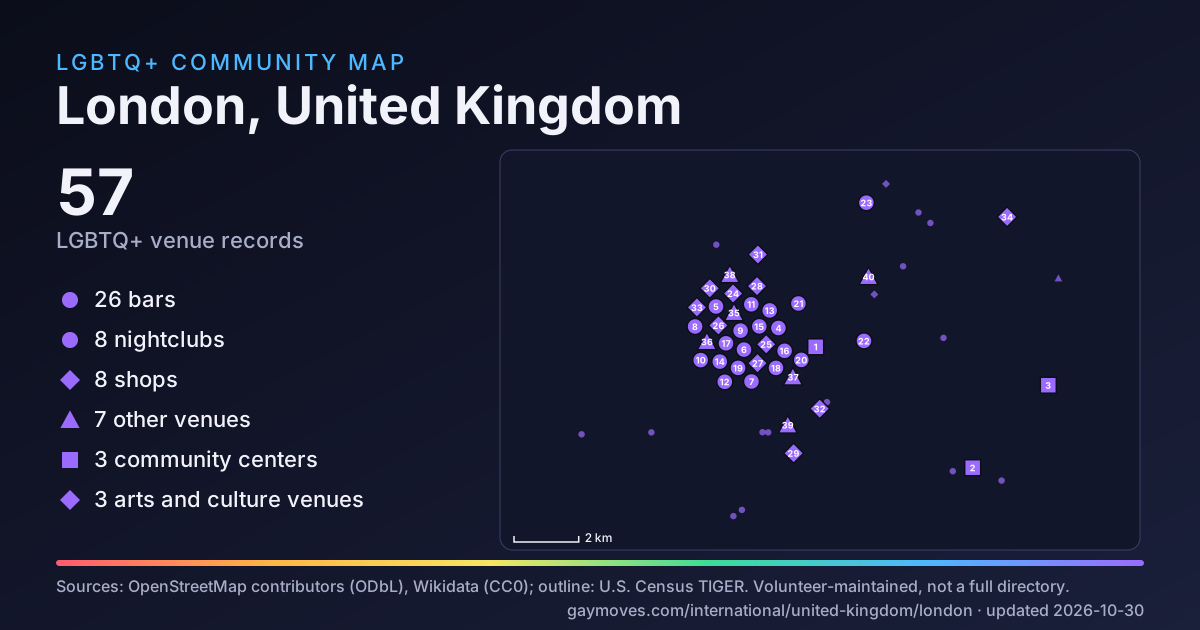
LGBTQ+ community map Download SVG
London questions
Answers are generated from the sourced data on this page and name their source.
Are there LGBTQ+ venues and community spaces near London?
OpenStreetMap and Wikidata hold 57 records tagged as LGBTQ+ venues, centers, services or Pride events for London: 26 bars, 8 nightclubs, 8 shops, 7 other venues. Both sources are volunteer-maintained, so the list is a starting point and not a full directory. Sources: OpenStreetMap contributors (via Overpass API) (https://www.openstreetmap.org/), retrieved 2026-10-30; Wikidata (https://www.wikidata.org/), retrieved 2026-10-30.
What is the nearest airport to London?
London City Airport (LCY) is the nearest commercial airport in the OurAirports data, 8 mi13 km in a straight line from the city center (not drive time). Source: OurAirports (https://ourairports.com/airports/EGLC/), retrieved 2026-10-30.
Are there LGBTQ+ friendly real estate agents in London on GayMoves?
Not yet verified. No agent has claimed London, United Kingdom on GayMoves, so we show none and invent none. Claiming starts a 30-day Pro trial with no card, and the first 25 agents to claim a city get 90 days instead (proposed terms).
Markets near London
Straight-line distance between place centers.
What we do not have yet
A block appears above only when it has enough sourced values. These do not, and we show nothing in their place.
This page is not offered to search engines yet (needs 4 sourced blocks, has 2; needs 3 city-level sourced blocks, has 2). It has 2 sourced blocks. It is indexed once it has at least 4 sourced blocks, 3 of them about the city itself.
Housing and demographics
The U.S. Census covers U.S. places only.
LGBTQ+ legal climate
The Movement Advancement Project covers U.S. jurisdictions only.
Climate
No NOAA 1991-2020 climate normals station was found close enough to this place.
Geography and getting there
Boundary, elevation or airport data is not available for this place.
Sources and last updated
Last updated 2026-10-30: the newest retrieval date of any source on this page. Numbers in square brackets point here.
[1] OpenStreetMap contributors (via Overpass API)
https://www.openstreetmap.org/
Retrieved 2026-10-30 · License: ODbL 1.0
© OpenStreetMap contributors
[2] Wikidata
Retrieved 2026-10-30 · License: CC0 1.0
Wikidata (CC0)
[3] GayMoves coverage-union anchor coordinates (US Census 2023 Gazetteer place centroid, rounded to 0.01 degree)
https://www.census.gov/geographies/reference-files/time-series/geo/gazetteer-files.html
Retrieved 2026-10-30 · License: Public domain (US Government work, 17 USC 105)
[4] OurAirports
https://ourairports.com/airports/EGLC/
Retrieved 2026-10-30 · License: Public domain (OurAirports dedication)
[5] OpenStreetMap contributors via Overpass API
https://www.openstreetmap.org/?mlat=51.50745&mlon=-0.12777#map=14/51.50745/-0.12777
Retrieved 2026-10-30 · License: ODbL 1.0, (c) OpenStreetMap contributors
Full license notes for every dataset are in the project's data license register. Estimates can change when sources publish new vintages.