Loading city directory
Open marketNo verified agents yetMetro areaData updated 2026-10-30
Greater Fort Lauderdale, FL: LGBTQ+ friendly real estate guide
A data-first guide to Greater Fort Lauderdale, FL for LGBTQ+ buyers, renters and people relocating: climate and geography. Every figure carries a numbered source and a retrieval date.
Units
LGBTQ+ legal climate in Greater Fort Lauderdale
State law for Florida and local ordinances are published by the Movement Advancement Project (MAP).
Read the laws at the source
We do not republish MAP's legal data here. Open the MAP Equality Maps below and choose Florida. Not legal advice; confirm with your state civil rights agency or a local fair housing organization.
- Movement Advancement Project, Equality Maps: Nondiscrimination Laws
- Movement Advancement Project, Equality Maps: Child Welfare Nondiscrimination Laws
- Movement Advancement Project, Equality Maps: Healthcare Laws and Policies
- Movement Advancement Project, Equality Maps: Conversion Therapy Laws
- Movement Advancement Project, Equality Maps: Local Nondiscrimination Ordinances
LGBTQ+ community map and venues in Greater Fort Lauderdale
Venues, centers, health and social services and Pride events tagged as LGBTQ+ in OpenStreetMap and Wikidata. Both are volunteer-maintained, so treat this as a starting point.
No venue records in our sources
No LGBTQ-tagged venues, centers, clinics or Pride events were found for this market in OpenStreetMap or Wikidata. These sources are volunteer-maintained, so this is a gap in the data, not a statement that none exist.
Climate in Greater Fort Lauderdale
Thirty-year averages (1991-2020) from the nearest NOAA station with normals, FT LAUDERDALE EXECUTIVE AP, 4.2 mi6.7 km from the city center at 13 ft4 m elevation.
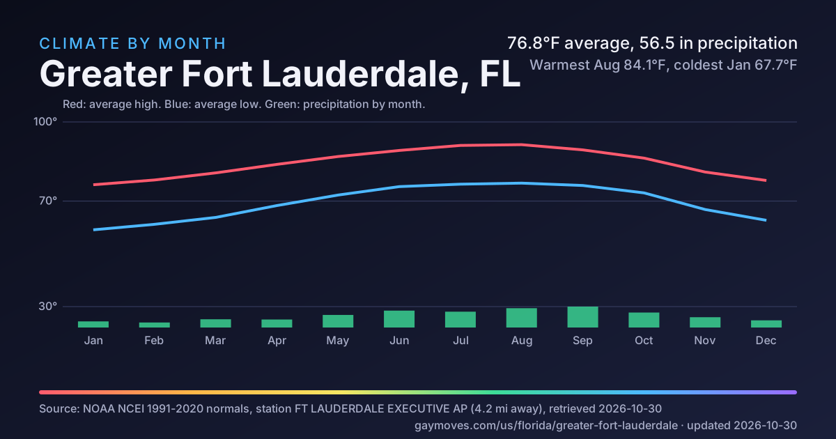
Red line: average high. Blue line: average low. Green bars: precipitation (tallest month 8.13 in).
Station FT LAUDERDALE EXECUTIVE AP, 4.2 mi from the city center. Normals for 1991-2020.
Show the data as a table
| Month | High °F | Low °F | Average °F | Precipitation (in) |
|---|---|---|---|---|
| Jan | 76.2 | 59.1 | 67.7 | 2.38 |
| Feb | 78 | 61.2 | 69.6 | 1.95 |
| Mar | 80.7 | 63.8 | 72.3 | 3.2 |
| Apr | 83.9 | 68.3 | 76.1 | 3.11 |
| May | 86.9 | 72.3 | 79.6 | 4.89 |
| Jun | 89.2 | 75.5 | 82.4 | 6.57 |
| Jul | 91.1 | 76.4 | 83.8 | 6.15 |
| Aug | 91.4 | 76.8 | 84.1 | 7.51 |
| Sep | 89.4 | 75.9 | 82.6 | 8.13 |
| Oct | 86.3 | 73.1 | 79.7 | 5.82 |
| Nov | 81 | 66.8 | 73.9 | 4 |
| Dec | 77.8 | 62.7 | 70.3 | 2.79 |
Red line: average high. Blue line: average low. Green bars: precipitation (tallest month 207 mm).
Station FT LAUDERDALE EXECUTIVE AP, 6.7 km from the city center. Normals for 1991-2020.
Show the data as a table
| Month | High °C | Low °C | Average °C | Precipitation (mm) |
|---|---|---|---|---|
| Jan | 24.6 | 15.1 | 19.8 | 60 |
| Feb | 25.6 | 16.2 | 20.9 | 50 |
| Mar | 27.1 | 17.7 | 22.4 | 81 |
| Apr | 28.8 | 20.2 | 24.5 | 79 |
| May | 30.5 | 22.4 | 26.4 | 124 |
| Jun | 31.8 | 24.2 | 28 | 167 |
| Jul | 32.8 | 24.7 | 28.8 | 156 |
| Aug | 33 | 24.9 | 28.9 | 191 |
| Sep | 31.9 | 24.4 | 28.1 | 207 |
| Oct | 30.2 | 22.8 | 26.5 | 148 |
| Nov | 27.2 | 19.3 | 23.3 | 102 |
| Dec | 25.4 | 17.1 | 21.3 | 71 |
- Average temperature
- 76.8°F24.9°C[1]Warmest Aug 84.1°F28.9°C, coldest Jan 67.7°F19.8°C
- Precipitation
- 56.5 in1,435 mm[1]Per year
- Days at 90°F32.2°C or hotter
- 93[1]Per year
- Days at or below freezing
- 0[1]Per year
- Heating degree days
- 146[1]Higher means more heating
- Cooling degree days
- 4,476[1]Higher means more cooling
Geography and getting to Greater Fort Lauderdale
Distances are straight-line from the city center, not drive time.
Moving to Greater Fort Lauderdale: a guide from the data
Every line below is generated from the sourced figures on this page. Nothing here is opinion or marketing.
Getting there and getting around
- Fly into Fort Lauderdale Hollywood International Airport (FLL), 4.7 mi7.6 km from the city center in a straight line.[4]
Weather to plan for
Questions to bring to any agent
General questions, not city data.
- Which neighborhoods fit my budget, and how do you know?
- How many LGBTQ+ clients have you represented, and can I speak to one?
- Which lenders and inspectors do you work with, and do you receive anything for referring them?
- How will you handle showings and offers if I am relocating from out of town?
- What is your fee, and when is it due?
Agents in Greater Fort Lauderdale
Not yet verified. No agent has claimed Greater Fort Lauderdale, FL on GayMoves, so we show none and invent none. Claiming starts a 30-day Pro trial with no card, and the first 25 agents to claim a city get 90 days instead (proposed terms).
Founding agent offerProposed terms
Be one of the first 25 agents in Greater Fort Lauderdale, FL
Claiming starts a 30-day Pro trial with no card, and the first 25 agents to claim a city get 90 days instead. After the trial Pro is $39 a month for up to 20 cities, and the Free plan stays free. Claiming means your own verified profile: no one is listed here on your behalf.
Share Greater Fort Lauderdale charts
Each card is a standalone image that prints its own sources and date. Save it, post it, or drop it in a message.
Climate by month Download SVG
Greater Fort Lauderdale questions
Answers are generated from the sourced data on this page and name their source.
Are there LGBTQ+ venues and community spaces near Greater Fort Lauderdale?
Not in our sources: OpenStreetMap and Wikidata list no LGBTQ+ venue record for Greater Fort Lauderdale. These sources are volunteer-maintained, so this is a gap in the data and not proof that none exist.
What is the weather like in Greater Fort Lauderdale?
Using 1991-2020 normals from the FT LAUDERDALE EXECUTIVE AP station (4.2 mi6.7 km from the city center): the warmest month averages 84.1°F28.9°C (Aug) and the coldest 67.7°F19.8°C (Jan). Annual precipitation is 56.5 in1,435 mm. Source: NOAA NCEI U.S. Climate Normals 1991-2020, Monthly (https://www.ncei.noaa.gov/data/normals-monthly/1991-2020/access/USW00012885.csv), retrieved 2026-10-30.
What is the nearest airport to Greater Fort Lauderdale?
Fort Lauderdale Hollywood International Airport (FLL) is the nearest commercial airport in the OurAirports data, 4.7 mi7.6 km in a straight line from the city center (not drive time). Source: OurAirports (https://ourairports.com/airports/KFLL/), retrieved 2026-10-30.
Are there LGBTQ+ friendly real estate agents in Greater Fort Lauderdale on GayMoves?
Not yet verified. No agent has claimed Greater Fort Lauderdale, FL on GayMoves, so we show none and invent none. Claiming starts a 30-day Pro trial with no card, and the first 25 agents to claim a city get 90 days instead (proposed terms).
Markets near Greater Fort Lauderdale
Straight-line distance between place centers.
- Fort Lauderdale, FLAbout 0 mi0 km away · Open market
- Wilton Manors, FLAbout 1.2 mi2 km away · Open market
- Oakland Park, FLAbout 2.5 mi4 km away · Open market
- Plantation, FLAbout 6.8 mi11 km away · Open market
- Hollywood, FLAbout 7.5 mi12 km away · Open market
- Delray Beach, FLAbout 22 mi36 km away · Open market
What we do not have yet
A block appears above only when it has enough sourced values. These do not, and we show nothing in their place.
This page is not offered to search engines yet (needs 4 sourced blocks, has 2; needs 3 city-level sourced blocks, has 2). It has 2 sourced blocks. It is indexed once it has at least 4 sourced blocks, 3 of them about the city itself.
Housing and demographics
Regional or metro market (NAGLREP chapter area), not a single Census place. No place-level ACS record applies.
LGBTQ+ legal climate
The Movement Advancement Project values are withheld until MAP confirms permission to republish them. Read them at the source (linked in that section).
Community map and venues
OpenStreetMap and Wikidata hold no LGBTQ+ venue record for this place (a gap in volunteer data, not proof that none exist).
Daily life
Commute, transit, parks and destination counts are not available for this place.
Sources and last updated
Last updated 2026-10-30: the newest retrieval date of any source on this page. Numbers in square brackets point here.
[1] NOAA NCEI U.S. Climate Normals 1991-2020, Monthly
https://www.ncei.noaa.gov/data/normals-monthly/1991-2020/access/USW00012885.csv
Retrieved 2026-10-30 · License: Public domain (US Government work, NOAA)
[2] GayMoves coverage-union anchor coordinates (US Census 2023 Gazetteer place centroid, rounded to 0.01 degree)
https://www.census.gov/geographies/reference-files/time-series/geo/gazetteer-files.html
Retrieved 2026-10-30 · License: Public domain (US Government work, 17 USC 105)
[3] USGS 3D Elevation Program, Elevation Point Query Service
https://epqs.nationalmap.gov/v1/json?x=-80.15&y=26.14&units=Meters&wkid=4326&includeDate=false
Retrieved 2026-10-30 · License: Public domain (USGS, US Government work)
[4] OurAirports
https://ourairports.com/airports/KFLL/
Retrieved 2026-10-30 · License: Public domain (OurAirports dedication)
Full license notes for every dataset are in the project's data license register. Estimates can change when sources publish new vintages.